874 miles from Lands End, John O'Groats is a well known village and ferry port near to the extreme north-eastern tip of the Scottish mainland. The village overlooks the Pentland Firth across which lie the Orkney Islands.


A tombstone preserved in the
church at nearby Conisby is that of one
John De Groot, a Dutchman who settled in the area in the 15th
century. He ran a ferry across the Pentland Firth for which he charged a fare of 4d and this little silver coin became
known as a ‘groat.’ So this man not only gave his name to a
coin but he also gave it to that famous village known today as John O’Groats. De Groot built an octagonal house, now demolished, on a small mound there –
the story goes that in order to settle a dispute and quarrels over precedence
amongst his seven sons, he built the house with eight doors to enable himself
and each of his sons to enter the house by his own door, and he furnished it
with an octagonal table so that each could sit at the ‘head’. The site in marked by the mound and a
flagpole. In 1875, a hotel with an
octagonal tower was built nearby.

.JPG)

Orkney is an archipelago 70 islands some 12 miles across the Pentland Firth of which only 20 are inhabited. The ferry from John O' Groats reaches South Ronaldsway, one of several smaller islands now connected by road to the Mainland which is in turn surrounded by the other islands mainly to
the north-east.
South Ronaldsway and the other small islands to the east of the natural harbour known as Scapa Flow, were connected during WW2 by what is known as The Churchill Barriers.
These barriers are a
series of four causeways which link the Orkney Mainland to South Ronaldsway via
the islands of Burray, Lamb Holm and Glimps Holm, a total length of 1.5 miles.
They were built in the 1940’s at the instigation of Winston Churchill as naval
defences to protect the naval anchorage in Scapa Flow. They now carry the A961
road from Burwick To Kirkwall.
In 1939 the Royal Navy
battleship, HMS Royal Oak was moored in Scapa Flow and on 14 October she was
sunk in a night time attack by a German U-boat which had entered this natural
harbour between the mainland and Lamb Holm island. 833 lives were lost and the
sunken battleship is a designated war grave marked by a buoy next to Scapa
Beach where there is a Memorial Garden.
Although the shallow
eastern passage into Scapa Flow had been protected by sunken block ships and
anti-submarine nets the U-boat was able to navigate around them at high tide
and escaped the same way. The barriers were constructed using Italian prisoners
of war to provide the labour. The use of POW labour for war effort work was
prohibited under the Geneva Convention but their use was justified as
‘improvement to communications between the islands’ which resulted in the
present day A961.
Gabions enclosing
250,000 tons of broken rock from local quarries were used as foundation and
were covered by 66,000 locally cast 5 ton concrete blocks with 10 ton blocks
alongside to act as wave breaks.
As a war grave, the remains of the Royal Oak are
protected by a ‘cage’ and diver’s are forbidden to trespass. However a diver
did recover the ship’s bell and after a period of time he handed the bell over
to the authorities and it is now preserved in Kirkwall Cathedral as a memorial
The Italian Chapel is a
very fine ‘tin tabernacle’ is situated on the tiny island of Lamb Holm.
During
WW11 550 Italian prisoners of war, captured in North Africa, were housed on
this previously uninhabited island between South Ronaldsway and The Mainland.
They were to be involved in the construction of The Churchill Barriers.
Prime
Minister, Winston Churchill, ordered four defensive concrete dykes to be
constructed across the eastern approach to Scapa Flow and they became known as
The Churchill Barriers. Today they carry a road linking the various islands,
including Lamb Holm, to The Mainland.
The
prisoners were housed at Camp 60 in 13 Nissen huts and they enhanced the camp
themselves with the use of the readily available concrete and in 1943 the camp
commandant authorised the use of two Nissen huts to provide a chapel for the
prisoners. The huts were placed end to end and the interior was lined with
plasterboard. The prisoners built a concrete façade complete with belfry to
conceal the shape of the Nissen huts which they thickly coated in concrete. One
of the prisoners, Domencio Chiocchetti, assisted by his fellow prisoners,
painted the interior which resulted in a magnificent and spectacular work of
art.
In
1960 Chiocchetti returned to Lamb Holm to restore his paintwork. This category
A masterpiece is now under the auspices of a preservation committee.
This tiny metal heart can be seen on the floor of the chapel close to the altar rail. The story goes that one of the Italian POW's fell in love with a local girl. He was a married man and when the war was over he was forced to return to his homeland. He left a note for his lover telling her that he had left his heart in the chapel.
Chiocchetti also fashioned a statue of St George from barbed wire and concrete which still stands near to the church.
Kirkwall, Orkney's capital, stands on the Mainland and is dominated by its red sandstone cathedral.
.JPG) |

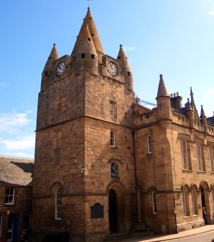
Kirkwall Town Hall
St Magnus Cathedral was founded in c.1035.
Remarkable archeological sites are to be found on the Mainland west of Kirkwall
The Ring of Brodgar stands on a strip of land between Lochs Stenness and Harray. It was built in about 2000BC as an astronomical temple of some 60 standing stones of which only 27 still stand, set in a circle 340 feet wide.
Nearby are the Standing stones of Stenness where only three of the twelve large standing stones that formed a circle remain.
Back on the mainland, the Falls of Shinn are a great attraction. The River Shinn flows from Loch Shinn into the Dornoch Firth and these picturesque falls can be visited near to Lairgs.
Dornoch is a pleasant family resort on the north shore of the Dornoch Firth.
The fine beaches are bordered by extensive golf links said to be amongst the finest in Scotland.
Welcome to Dornoch
This very interesting former Royal Burgh grew up around its fine cathedral built in the 13th century on the site of a 6th century chapel.
The Cathedral was destroyed by fire in 1570, redesigned in the 17th century and almost entirely rebuilt 1835-1837. It was restored in 1924.
The Cathedral graveyard which was once part of the market place, preserves a flat stone just 37” long formerly used for measuring cloth
on sale in the market.
The Scottish ‘ell’ was a measurement equivalent
to 37 inches. It was very important in
the Scottish market place that this measurement was strictly adhered to and
officials made every endeavour to ensure that it was.
The building on the right was the Bishop's Palace. Dating from the 16th century it is now a luxury hotel.
Opposite the cathedral in Castle Street is the old 19th century jail which had 11 cells and keepers accommodation. It is now a modern shop sympathetically combining the sales areas with the old cells which can be readily seen.
In a small garden not far away from the jail, a simple stone known as The Witch's Stone. It
bears the date 1722 and is said to mark the spot where the last witch was burnt in Scotland. Janet Horn had been accused of ‘turning her daughter into a pony and
having her shod by the devil!’
A stone, which is situated in a remote spot on the
edge of woodland behind Earl’s Cross House to the east of Dornoch, is supposed
to mark the grave of a cholera victim. The body was brought to Dornoch in 1832
for burial but was refused entry by guards and was buried near this memorial
stone instead. Such was the stigma of the disease that his son wrote a
denial on the stone :
ERECTED
BY K.R
over the remains
of his dutiful Father
K.R who departed this
life July 24 1832 aged 44
years. It was then suppo
sed he died of cholera
but afterwards contra
dicted by most eminent
medical men.
Another stone at Dornoch is not quite what it seems to be.
Although the stone is inscribed St Michael’s Well it is not
over the well.
The northern boundary of Dornoch is at
a point called St Michael’s Well but this boundary stone does not mark the true
boundary.
The stone was put in this position, a short distance north
of the well, in 1832 by one George Gunn who was land factor to the Duke of
Sutherland. Gunn had an ulterior motive for his action because a new law
declared that only those living within 7 miles of the Burgh boundary could vote
in the local elections. Unfortunately George’s home was at Rhives near Golspie just
outside the 7 miles limit, so he had the stone hewn, inscribed and erected
within the 7 miles
and thus he retained his right to vote.
Paper
epitaph
A whisky bottle found under the floorboards of a house in
Dornoch, contained a piece of paper on which was written :
‘ In memory of A Gray and Hugh McKenzie
whitch Drunk this Bottle of Whisky.
1984.’
Both the bottle and the epitaph are preserved in
Historylinks Museum in Dornoch.
Across the Dornoch Firth, Tain is Scotland's oldest royal burgh where there is an elegant Tolbooth dating to 1707.
The pretty village of Portmahomack is also on the south shore of
the Dornach Firth.
The Oystercatcher Seafood Restaurant on the sea front doesn't have any Michelin Stars but it does have two Michelin tyres!
Balintore is a small seaside village overlooking the Moray Firth with fine views across the firth to the Moray Coast.
Sitting on a rock is the charming sculpture of a mermaid.
Local legend has it that the mermaid was captured by a young fisherman who hid her tail. The couple married an raised a family but when the mermaid later found her tail she went back into the sea.
Nigg Old Church is now redundant but is well preserved.
The church preserves a very fine Pictish cross
slab which was formerly in the churchyard.
There is also a fine survivor from former times in the shape
of a 'Poor Loft' which is now blocked off. This area was not for poor people -
quite the opposite. People occupying these pews in the 19th century paid a 'pew
rent' which was a way of raising money for the Parish Poor Fund.
Poor people
had to stand in the body of the church.
A local story has it that in the 19th century the church
beadle allowed an illicit still to be kept in the space under the pulpit!
There is a cholera stone in the churchyard which dates from
the cholera epidemic of 1832. The story goes that an elder of the church saw a
cloud of vapour hovering above the ground in the churchyard. Believing it to be
a cloud of cholera, he threw a blanket or cloth over it and placed the large
stone on top
to keep it from escaping.
|

.JPG)


.JPG)
.JPG)


.JPG)


.JPG)


.JPG)


.JPG)
.JPG)

.JPG)
.JPG)
.JPG)


.JPG)
.JPG)
.JPG)
.JPG)
.JPG)
.JPG)
No comments:
Post a Comment