The A887 road travels west from Loch Ness through Glen Moriston and follows a route all the way to the Skye Bridge.
Roderick MacKenzie was not only a supporter of Bonnie
Prince Charlie at the Battle of Culloden in 1746, but he was also strikingly similar in
appearance to the Prince. So much so
that after the battle was lost, MacKenzie was used as a double to deceive the
British troops into thinking that they had found the Prince who had
in fact made good his escape over the sea to Skye.
MacKenzie was killed in Glen Moriston not far from Loch Ness where a
cairn marks the spot and bears a commemorative plaque. The cairn is situated alongside the southern
side of the A887 just 2 miles east of its junction with the A87.
.jpg)
.jpg)

The A87 continues through the delightful scenery of Glen Shiel where the five Sisters of Kintail rise majestically to the north to a height of 3504 feet.
 |
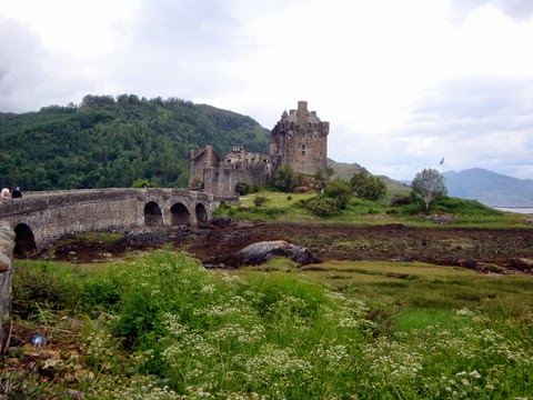
Situated on an islet between Loch's Duich and Alsh is the photogenic Eilean Donan Castle made famous in the film Highlander. Dating from c1220 it was named after a Celtic hermit and became a stronghold of the Mackenzie Clan in the 14th century. The casle was restored to its former glory in the 1920's.    |
The Kyle of Lochalsh is named after the narrow strait which separates it from the Isle of Skye. The cantilever bridge over the strait, which was opened in 1995 is said to be the most expensive bridge in Europe. It was privately built as a toll bridge amidst much controversy over the abolition of the ferry service.
It is now toll free.

.JPG)


Skye is the largest island of the Inner Hebrides with spectacular mountain scenery. It is the stronghold of Gaelic culture and traditions, the place of romance and tradition.
Brightly painted houses border the harbour at Portree, the only town on the island.


A room at The Royal Hotel is pointed out as that in which Bonnie Prince Charlie said goodbye to Flora Macdonald in 1746.

Back on the mainland, the A890 road starts the torturous route up the spectacular west coast alongside the lovely Loch Carron.
.JPG)


It wouldn't be quite the same without the ubiquitous highland cow.

At the head of Loch Carron the A896 road leads up through wild landscapes described by Queen Victoria as totally isolated from civilisation to the little village of Shieldaig with its peninsular dividing Upper Loch Torridon from Shieldaig which in turn leads in to Loch Torridon.


Ullapool was developed as a fishing port in the 18th century to exploit the rich herring shoals of Loch Broom on which the village stands. Ferries leave the harbour for the Isle of Lewis.
.JPG)
Near to Elphin the double peak of Suilven rises 2399 feet beyond Cam Loch.


Here a the A837 road branches off towards Dornoch on the east coast.
On this road Oykell Bridge crosses the River Oykell
in very picturesque surroundings.


Continuing northwards the scenery never fails to disappoint.


Durness is on the north coast just down from Cape Wrath which is the most northerly point of Scotland's north-west seaboard.
Nearby, Smoo Cave is a huge cave in a cove in the steep cliffs. There are three chambers and in the outer one Allt Smoo burn tumbles some 80 feet from a hole in the roof. The cave can be accessed on foot at low water.


Loch Eriboll is one of the most impressive sea lochs penetrating deep into the Sutherland Mountains and surrounded by impressive countryside.
Its maximum depth is 394 feet and was a safe anchorage in WW2,


The lonely tin church at Syre is a stark reminder that throughout the 19th century, landlords
evicted Highland tenants from their crofts in order to replace them with
marginal smallholdings with extensive sheep farms attached. Their methods were very harsh often using
violence together with the burning of the houses. Many thousands of these Highlander’s had no option but to emigrate, leading to the
depopulation of the Highlands. In 1886
following growing civil disobedience, the Napier Commission’s report resulted
in the passing of the Crofting Act, giving crofter’s security of tenure,
bringing the clearances to an end, but did nothing to restore land already
cleared. Whole villages were cleared in
this part of Sutherland leaving a bleak wilderness to the sheep.

No comments:
Post a Comment